
封面故事
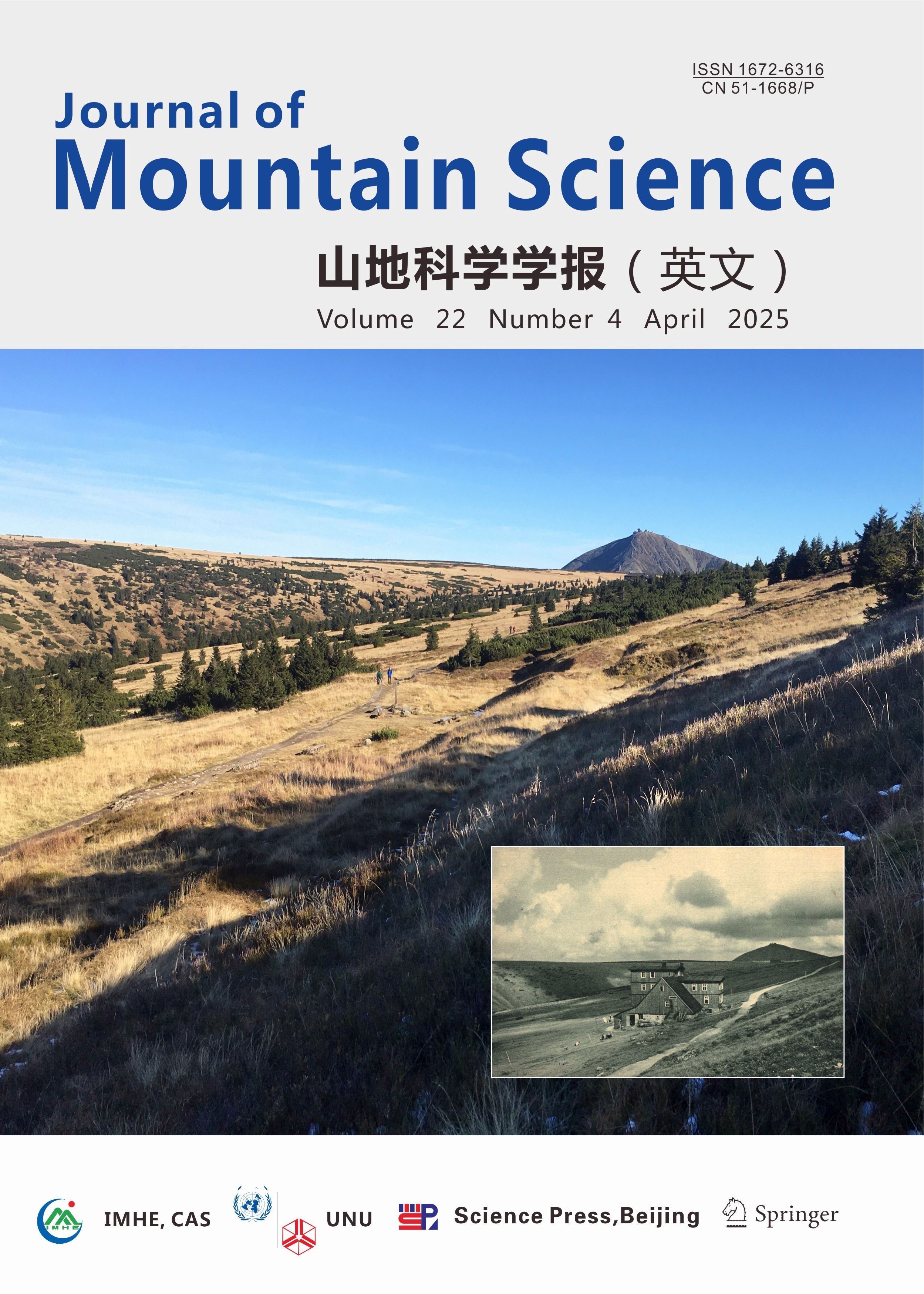
在封面照片的背景中,你可以看到克尔科诺谢山(Krkonoše, 克尔科诺谢山是捷克与波兰的界山,又名"巨人山")的最高峰——海拔1603 米的斯涅日卡山(Sněžka),这也是整个捷克的最高峰。斯涅日卡山以其规模、海拔高度、冰川和冰缘地貌以及北极高山苔原等特征,在中欧也是独一无二的。在照片的前景中可以看到一个不起眼的平台,上面有几根长凳和一些混凝土块。1938 年消失的 Rennerova bouda(小木屋)曾经矗立在这里。作者所站的位置就在通往小木屋的小路上方,而现在这条小路在地形中几乎看不到了。现在的夏季小路位于更低的位置,在历史照片中仅以标示冬季小路的杆子的形式出现。彩色照片是2021年10月由托马什-赫伊达(Tomáš Hejda)在实地考察时所拍摄,黑白照片显示的是1921年的同一地点。从这些照片中,我们可以观察到土地利用和覆被的显著变化和景观变化。过去的山区农耕景观(放牧和干草生产)变成了国家公园(于1963 年宣布),并设立了非干预区。100 年间,长满青草的苔原上已经长满了茂密的矮松和云杉。这一过程既有自然因素(气候变化)也有人为因素(土地撂荒和植树造林)的驱动。
在本期(《山地科学学报(英文)》第22卷第4期)上,题为 “自20 世纪中叶以来捷克克尔科诺谢和赫鲁比耶塞尼克山脉山间小屋农业衰落后的土地利用/土地覆被变化”的文章,展示了从山间小屋农业结束(约1945年)至今,在捷克克尔科诺谢山脉和赫鲁比耶塞尼克山脉的3个地点的土地利用/土地覆被变化,并比较了各地点和山脉之间的结果。
本研究采用遥感方法,并辅以树木年代学和实地调查。这些方法的组合应用相对比较独特,目前尚未见到在赫鲁比耶塞尼克山脉的环境变化研究中应用。本研究旨在捕捉农耕结束后土地利用/土地覆盖的变化,并与现在的情况相叠加,以确定区域土地利用和覆被变化的驱动力,并确定土地废弃后草地飞地次生演替的开始时间。鉴于目前山区特别是中欧地区的气候波动,这项研究非常及时且意义重大。
Cover Story
On the title photo you can see in the background the distinctive peak of the highest mountain of the Krkonoše Mountains, and the whole Czechia, Sněžka 1 603 m above sea level, which is unique not only in Central Europe with its size, altitude, glacial and periglacial relief and arctic-alpine tundra. In the foreground of the photograph, an inconspicuous platform with several benches and concrete blocks can be seen. Rennerova bouda (chalet), which disappeared in 1938, used to stand on this spot. The author is standing immediately above the former path to the chalet, which is now little visible in the terrain. The current summer path, which lies even lower down, appears only in the form of a pole marking as a winter path in the historic photograph. The colour photograph was taken during field research by MSc. Tomáš Hejda in October 2021. The black and white photograph shows the same place in 1921. From the photographs we can observe a significant land use/land cover change and landscape change. The mountain cultivated landscape (cattle grazing and haymaking) was turned into a national park (declared 1963) with a non-intervention zone. In 100 years, the grassy tundra plains have become quite densely overgrown with dwarf pine and spruce. This process is both natural (climate oscillations) and anthropogenically driven (land abandonment and afforestation).
In the current issue (Journal of Mountain Science Vol. 22 No. 4), the article entitled "Land use/land cover changes after the decline of mountain chalet farming in the Krkonoše and Hrubý Jeseník Mountains, Czechia, since the mid-20th century" presents land use/land cover changes at 3 sites in the Krkonoše Mountains and 3 sites in the Hrubý Jeseník Mountains in Czechia from the end of chalet farming (ca. 1945) to the present and compares the results between sites and mountains. The research was carried out using remote sensing methods, supported by dendrochronological and field surveys. The combination of these methods is relatively unique and has not yet been applied in the environment in the Hrubý Jeseník Mountains. The main objective was to capture land use/land cover changes immediately after the end of bud farming with an overlap to the present and to identify the driving forces of change in the study areas and to determine the timing of the onset of secondary succession in meadow enclaves after land abandonment. The research is timely and significant given the current climatic fluctuations in mountain environments, specifically in Central Europe.
下载阅读全文:202504 vol 22 no 4 cover article.pdf
引用:Hejda T, Kupková L, Boudný Z (2025) Land use/land cover changes after the decline of mountain chalet farming in the Krkonoše and Hrubý Jeseník Mountains, Czechia, since the mid-20th century. Journal of Mountain Science 22(4). https://doi.org/10.1007/s11629-024-9143-5
第一作者:HEJDA Tomáš(博士生)
托马什-赫伊达是布拉格查尔斯大学理学院社会地理与区域发展系的一名博士生。他的科研兴趣主要集中在景观结构(主要是中欧的高山无树地区)及其历史背景的分析,主要使用地理信息系统(GIS)和遥感技术,特别是航空摄影,进行空间数据的收集、处理和可视化。他是 “灌木和乔木的生长差异——木本植物的形态如何影响其在寒冷地区的生长能力?” 一文的作者。他还撰写了综述文章“克尔科诺谢山和赫鲁比耶塞尼克山高山无树地区土地利用的变化:对当前知识现状的总结和历史发展的比较》,其中论述了克尔科诺谢山和赫鲁比耶塞尼克山自人类定居以来土地利用的历史发展。他的最新研究 “自20 世纪中叶以来捷克克尔科诺谢和赫鲁比耶塞尼克山脉山间小屋农业衰落后的土地利用/土地覆被变化”对这一问题进行了跟进。
Tomáš Hejda is a PhD student at Department of Social Geography and Regional Development, Fauclty of Science, Charles University, Prague. His scientific interests and research are primarily focused on the analysis of landscape structure, mainly the alpine treeless region in Central Europe, and its historical context, mainly using geographic information systems (GIS) and remote sensing, especially aerial photographs, for spatial data collection, processing and visualization. He is the author or co-author of the articles "Differences in growth between shrubs and trees: How does the stature of woody plants influence their ability to thrive in cold regions?" He also prepared the review "Changes in land use of the Krkonoše Mountains and the Hrubý Jeseník Mountains alpine treeless: a summary of the current state of knowledge and a comparison of historical development", in which he addresses the historical development of land use in the Krkonoše Mountains and Hrubý Jeseník Mountains since the beginning of settlement. He followed up on this issue with his latest study "Land Use/Land Cover Changes after the decline of Mountain Chalet Farming in the Krkonoše Mountains and Hrubý Jeseník Mountains, Czechia, Since the Mid-20th Century".
通讯作者:KUPKOVÁ Lucie (博士,副教授)
露西-库普科娃是查尔斯大学理学院(www.tilspec.cz)应用地理信息和制图系的副教授兼系主任。她取得了环境保护硕士学位,并在2001年获得应用与景观生态学博士学位。她的主要专长是通过机载(主要是无人机)和卫星多光谱及超光谱数据监测植被动态和健康状况。她在多个领域开展研究项目,包括监测欧洲北极-高寒苔原植被、森林健康、入侵物种传播、捷克长期土地利用/土地覆盖变化,调查捷克已灭绝景观以及捷克的次城市化/城市化。她是理学院图像和实验室光谱学研究小组的负责人。自 2012 年以来,她一直致力于在克尔科诺谢山开展各种环境研究,其团队开发了基于无人机的植被监测方法,该方法已由克尔科诺谢国家公园管理局付诸实践。她是全球海洋渔业信息网-全球金色海洋信息网中南欧和东欧区域信息网络的区域协调员、国际地理联合会土地利用和土地覆盖变化委员会指导委员会成员,以及欧洲遥感中心保护从业人员支持小组成员。
Lucie Kupková is an Associate Professor and head of the Department of Applied Geoinformatics and Cartography, Faculty of Science, Charles University. She completed her master studies in environmental protection and her PhD in applied and landscape ecology in 2001. Her main expertise is in monitoring vegetation dynamics and health through airborne (mainly UAV) and satellite multispectral and hyperspectral data. She conducts research projects in various areas, including monitoring of European relict arctic-alpine tundra vegetation, forest health, invasive species spread, long-term land use/land cover changes in Czechia, investigates extinct landscapes in Czechia, and sub/urbanization in Czechia. She is the leader of a research Team of Image and Laboratory Spectroscopy at the Faculty of Science (www.tilspec.cz). She has been working on various environmental studies in the Krkonoše mountains since 2012 and her team developed methodology for UAV-based vegetation monitoring which has been implemented in practice by the Krkonoše National Park Administration. She serves as a regional coordinator for the South Central and Eastern European Regional Information Network of GOFC-GOLD, a member of the Steering Committee of the International Geographical Union Commission on Land Use and Land Cover Change, and a member of the Eurosite Remote Sensing support group for conservation practitioners.
转载本文请联系原作者获取授权,同时请注明本文来自邱敦莲科学网博客。
链接地址:https://wap.sciencenet.cn/blog-314423-1483884.html?mobile=1
收藏